 After my ‘once in a lifetime’ trip to the top of Kilimanjaro with my son, friends asked what my next adventure would be. My reply was ‘I have no plans’.
However, the annual SLA conference in San Diego at the beginning of June provided an opportunity to revisit an adventure from my youth. Aged 18, during my gap year between school and university, I flew to the Philadelphia, bought a Suzuki GS750 motorbike and rode over ten thousand miles around the United States and Canada. Although it was certainly a big journey, the confidence that youth brings, meant I was not in awe of the scale of the undertaking. Each morning I just got on the bike and headed on towards the next suitable camp-site for the night with my ‘one-man’ tent. It was all about the journey and encounters made on the way, rather than any particular destination.

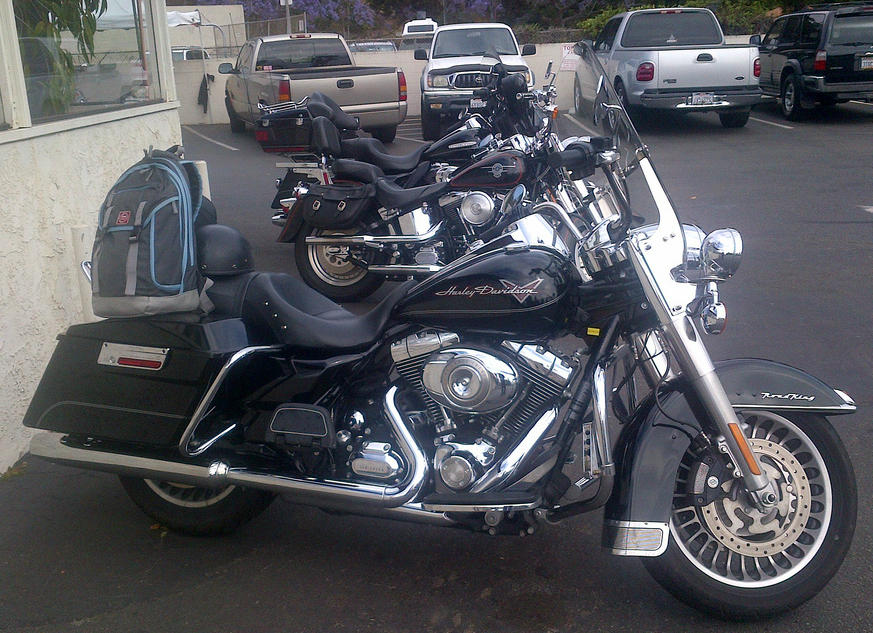
Thirty five years on I decided to make sure I had the ‘right’ bike for the trip. Which meant hiring a Harley Davidson Road King for the two long days of riding from San Diego to Las Vegas and back. In my younger biker days, Harleys or Hogs as they are affectionately known to their fans, were something of a joke in the UK. They were infamous for their unreliable low power ‘agricultural’ engines, their inability to lean around even the mildest of bend without something hitting the road, or even more worrying, the ability to stop when required.
But driving through Death Valley in the heat of the day, on the Suzuki 750 all those years ago, gave me a new appreciation of the benefits of a solid slow cruiser that would run all day at 60mph with the engine ticking over a lazy pace.
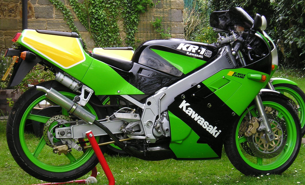
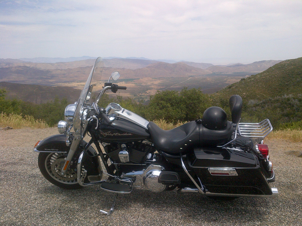
I snuck away from the final session of the excellent 2013 SLA conference, and headed up to the offices of Eagle Rider located in Old Town San Diego. It was at this point the scale of the undertaking began to dawn on me. On first sight the bike was even bigger than I was expecting. Sparkling in the bright sun from its many chromed surfaces, it was simply enormous. Weighing in at 385kg and packing a 1700cc V-twin air-cooled engine it looked too heavy to hold upright, let alone ride the 450 miles to Vegas. Before the trip I had joked to friends how different this bike would be compared to my pocket rocket Kawasaki KR-1S safely tucked away in my garden shed at home.
The Road King was literally three times heavier, and seven times bigger in the engine department.
- … and large
And the harsh reality of this monster Harley was unnerving to say the least. This wasn’t helped by finding out that the local riders’ idea of a crash helmet barely covered the top of my head. After a somewhat cursory introduction by Andy from Eagle Rider, who does this many times a day, I was ready to hit the road.
Literally hitting the road and ending up in hospital was precisely what I sat there worrying about for a few minutes. Until Andy popped his head out of the office and asked if I was ok. My response was a falsely confident wave and a reluctant prod with my thumb on the starter button. The engine cranked into life and settled into a chug-chug burble. I stomped it into first gear and wobbled out of the parking lot into the San Diego evening rush hour.
Half an hour later I was back at my hotel dripping with sweat and cursing this unrideable dinosaur of a bike. As I struggled to park without dropping it in the street, Laura (my conference mentee) appeared from nowhere and said hello. I spent the next five minutes lambasting the bike’s failings as well as my inability to ride it properly. Her considered response was that it ‘looked cool’.
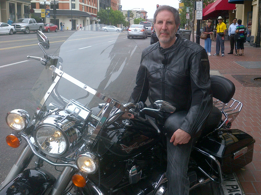
After an unsettled night and a ‘last’ breakfast with my fellow conference attending Brits, it was time to set off. If you look closely at the photo below, you can see the look of trepidation in my eyes.
The first major challenge was filling up the tank with ‘gas’. The option to pay with cash didn’t work so I tried using my credit card. That didn’t work either, as I didn’t have the required US zip code. I popped into the kiosk to ask for help and learned that you have to pay cash in advance. After filing up, the cashier pointed the way to Interstate 8 East to take me out of town to begin my trip.
The first half-hour of riding was spent working out in my head how I would explain to my friends why I had taken the bike the straight back to Eagle Rider. The next half-hour had me contemplating a half-day riding round the beautiful windy roads of the exotically named Volcan Mountains Wilderness Preserve. Certainly the sights of birds of prey circulating above, plus what I think was a Coyote with a fresh kill in its mouth, distracted me from the challenge of getting the bike round the next tight bend in the road.
By the next half-hour I was starting to consider the possibility a slightly longer journey. And after a break for a desperately needed drink at the Miner’s Diner in tiny Julian CA, I finally decided to keep going and see how far I could get before dark. The unexpected gift of a large piece of scrumptious home-made apple pie (shades of Twin Peaks) certainly helped cheer my mood.
![]() Fortunately, thanks to a suggestion at the conference by fellow librarian biker Jill Strand, I was now in possession of a Butler Motorcycle map of Southern California. This showed all the best (windiest and traffic free) roads in the area, and I used it to plot a scenic route towards Las Vegas. Early on I learned two important things about Californian roads. One, they are very poorly signposted, with an assumption you have satellite navigation, or are a local and know where you are going. I lost count of the number of times I had to stop and ask for directions. Two, when the warning sign on the approach to a corner says 10mph it means 10mph (for me on the Road King anyway). The first couple of times I used my UK tactic of adding 10mph going into the corner, and nearly didn’t make it around the bend at all. After a couple more heart-stopping moments I followed the signs advice religiously.
Fortunately, thanks to a suggestion at the conference by fellow librarian biker Jill Strand, I was now in possession of a Butler Motorcycle map of Southern California. This showed all the best (windiest and traffic free) roads in the area, and I used it to plot a scenic route towards Las Vegas. Early on I learned two important things about Californian roads. One, they are very poorly signposted, with an assumption you have satellite navigation, or are a local and know where you are going. I lost count of the number of times I had to stop and ask for directions. Two, when the warning sign on the approach to a corner says 10mph it means 10mph (for me on the Road King anyway). The first couple of times I used my UK tactic of adding 10mph going into the corner, and nearly didn’t make it around the bend at all. After a couple more heart-stopping moments I followed the signs advice religiously.
The scenery on the way up through Warner Springs and on to Hemet was stunningly beautiful. Alternating from wild scrubland to horse ranch prairies with exotic names such as Sycamore Canyon Stables and Paradise Valley Ranch. The next challenge was finding my way through Hemet and on to the San Bernardino National Forest. After many miles of almost deserted highways, the road gradually became urbanised and busy with traffic. Once again there were no signs other than for the individual streets I was crossing. At a set of traffic lights I asked a likely looking pick-up truck driver for help. He said ‘just keep going straight forward’, so I did. Five miles later the buildings and traffic began to lessen, and then I was back out on my own again in the wild country.
This time the road climbed up into the quaint Cherry Valley and back down into Yucaipa. It was time for more fuel before heading up into the mountains again in search of Big Bear Lake. Despite being a city of over 50,000 people, it took me ages to find a working gas station. Finally I found a shiny new one with the owner on-hand inspecting his pride and joy. Unfortunately for me I was a week too early, and I left the forecourt with his repeated refrain ringing in my ears, ‘come back next week, when we are open’.
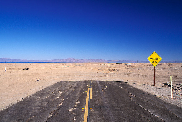
After locating what seemed to be the only functioning gas station in town, I asked for directions again with my trusty map to hand. Sadly the woman on the till only knew the way to the nearest interstate and nothing more. I could see where the mountains were beyond the edge of town, so headed in that direction. After a confident start the dual carriageway turned into a single highway, and then rather abruptly it ended somewhat like the photo below.
I struggled to turn the bike around and once again I searched for a likely looking local to ask for directions. This time I struck gold and was given clear instructions which worked. However, I experienced the same slightly odd phenomenon of the road gradually becoming less urban, and then quite suddenly I was out on my own again.
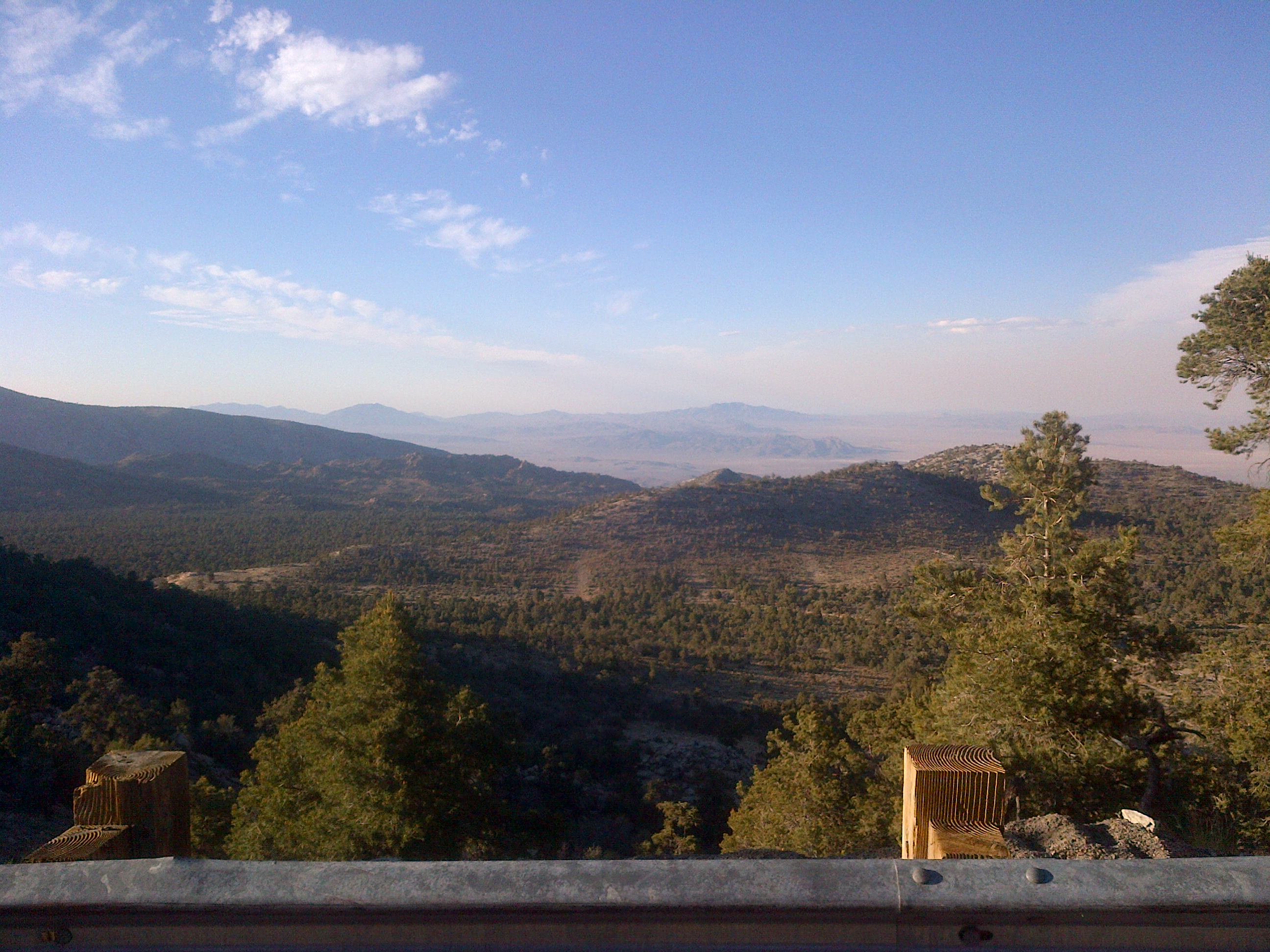
This time the road wound its way steeply up towards Onyx Peak at nearly 9,000 feet high. The air cooled noticeably and there was a delicious scent of mountain pine. The regular signs warning of rock-falls helped me concentrate on the road ahead though. It was around this time I became aware of the particular style of acknowledgement from other Harley riders. Back the UK about half the bike coming the other way will give a nod or a cursory wave. But in the US it is more a stretched out arm with a couple of fingers pointed. All done in the most casual style to ensure ‘coolness’ is maintained. Needless to say there is a video explaining it all in detail on YouTube.
As I wound my way down the mountain to Big Bear Lake, I wondered if the name was still pertinent. I it probably was, so decided not to stop and investigate the size of the furry inhabitants.
Next stop was the gas station in Big Bear, which had no gas, (I could see a pattern starting to emerge). But it did have ‘rest rooms’ and desperately needed water to combat the dehydrating heat. Another tip of ‘just keep on this road’ took me out of town and up into spectacular views east towards the desert and somewhere over the horizon Las Vegas itself.
Some more 10mph corners led down to dusty scrubland plains dotted with occasional houses. Cars were now down to less than one a mile, so I hoped the bike wouldn’t leave me stranded here, or that I would veer onto the sandy edge of the road and crash. With the sun setting in the west I cranked up the big lumpy engine and headed north towards Barstow and Interstate 15.
I reasoned I would be able to cope riding in the dark on the brightly lit motorway. This turned out to be a bit optimistic as the road wasn’t lit. But the sheer volume of traffic including great big Peterbilt and Kenworth eighteen-wheelers showed the way ahead. Once I hit the interstate I managed to work out how to get the cruise control working, and at last was able to give my right-hand some much needed rest. As by this time my fingers were starting to go numb from the engine vibrations. Much like at home in the UK, the 70mph speed limit meant 80mph in practice. And although the bike would definitely have gone faster with a quoted top speed of 110mph, I didn’t feel safe over 75 or so. This meant I was battered by a constant flow of big rigs cruising past with blasts of turbulence in their wake. If that wasn’t enough to worry about, powerful gusts of wind coming across from the desert were buffeting me. So I was in constant fear of getting blown off the bike. The bike itself remained unruffled and brushed off every eddy and gust with barely a reaction. Finally the great weight and plodding engine started to make sense.


I needed one more fill-up to make it to Vegas, so stopped in Baker just short of the Nevada border. Even in the dark I could see there wasn’t much to the town apart from gas stations and fast food joints. A recommendation from the petrol pump attendant sent me down to the Mad Greek which was much like the ubiquitous American burger joint, but with a Greek twist. I ordered a large coffee and ate a self-destructing burger while admiring their odd list of famous Greeks (plus honorary Greeks such as Winston Churchill), whilst contemplating my remaining 100 miles.
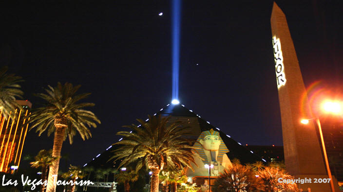
Powered by the coffee and with cruise control set to 70mph, I made it on to Primm, a very poor substitute for Las Vegas (smaller and tackier) just over the state border. As I piled on the miles I began to detect a glow in the distant sky, which I hoped would be the lights of my destination. Soon I could see a beam of light pointing skyward from what turned out to be the Luxor hotel. Gradually the familiar sights of Las Vegas came into view and I turned off the interstate for a cruise up and down the famous Vegas strip.
Having been down to the Stratosphere Tower and back I decided to chance my arm on getting a cheap room at the source of the beam of light which had guided me in to town. It was midnight by now, but the streets were still busy with traffic and drunken pedestrians, with a surprising number of them UK Northerners. A little gentle negotiating with the friendly receptionist from Chicago resulted in a $40 room (plus taxes of course), plus the $20 drinks voucher for spending in the hotel bars. A desperately needed shower and change had me back out on the streets by 1am, once I had used up my drinks voucher on a Mai Tai cocktail. Things were a bit quieter now with families with really quite young children in tow making their way back to their rooms.
Some of these children looked as young as eight and needless to say looked as tired as I felt. I manage to make it half-way along the strip, gawping at the bold architectural statements lining the road, each one more outrageous than the next. Despite the bright neon lights and in some cases pyrotechnics competing for my attention, it was the balletic splendour of the Bellagio Fountains that made the biggest impression. Sadly the Harley Davidson café was closed so I wasn’t able to ask about the incongruous Harley hedges growing outside. I couldn’t resist stopping to chat to a group of friendly Vegas bikers lined up next the road. We briefly compared notes on the various Harley models now that I was an ‘expert’ on the Road King after one day of riding.
Just a few yards from home I bumped into a man holding a sign (a common sight in America) offering ten minutes of reflexology for ten dollars. As a fan of its restorative qualities I couldn’t resist, and was led to a dark and sweaty room populated by a pack of drunken northerner Brits spending their last dollars on this treat. I resisted my therapists attempts to extend my treatment in exchange for another $10, and headed back to the Luxor for some desperately needed sleep.
I was now starting to worry about meeting my 5pm deadline for returning the bike the following day, so left the curtains open to let the sun help wake me up. I neglected to check what time the sun rises Nevada in June so was woken at 6am by the bright morning light. I couldn’t get back to sleep properly so packed away and prepared to set off back to San Diego. First stop was the gas station across from the hotel, where I noticed a group of Volvo cars all with laptops on the front seat. As a Volvo owner myself I quizzed one of the drivers and discovered they were company men from Sweden testing out secret new features on the cars. I wondered what they thought of life on the desert roads around Las Vegas.
 I decided the only safe way to get back in time was to stick to interstate 15 all the way across towards Los Angeles and then down to San Diego. A stop for fuel back in Baker in the heat of the early morning had me tempted by the Alien Beef Jerky store, but I had no additional room on board the bike.
Next stop was Victorville where I refuelled my body with a large coffee and small burger from local favourite fast food chain the In-N-Out Burger. A California based alternative take on the ubiquitous burger restaurant where the burgers are cooked to order, and the staff are paid more than the state minimum.
I was starting to get fed up of the persistent heat, humidity and increasing volumes of traffic on the interstate, and decided to head for what I hoped would be a cooler route along the Pacific coast. The bikers map showed a gold standard road winding over the Santa Anna Mountains to the ocean and Interstate 5 the Pacific Highway. I managed to find the turn-off despite a severe lack of signage, but soon got lost in the back streets of Perris. Once again I asked a likely looking local in a pick-up truck ‘which way to the Pacific?’ His response was (cue the hillbilly accent), ‘the Pacific? … I don’t know!’ Considering it was just twenty or thirty miles away through the hills, I was not impressed. I tried again with a younger version, and this time was pointed in the right direction with the warning that it was ‘dangerous up there in the hills’. Apart from the risk of not making it around one of the tight bends, I couldn’t see what he was worried about. But it seems many of the locals never stray far from the main highways.
However, it was slow going on this beautifully scenic and windy route up through Caspers Regional Park, and I began to worry again about missing my deadline. After more minimalist road signage, I managed to find the Pacific Highway and headed south in heavy traffic. Fortunately I was right about the temperate and revelled in the cool ocean breeze. It took thirty miles before I encountered a sign telling me how far I had left to San Diego. It was 53 miles and I had an hour and half to make it. I began to relax and allowed myself a quick stop at Aliso Creek viewpoint, which also happened to be a naval helicopter training site. So I spent five minutes being buzzed by Huey helicopters and having my photo taken.

With just ten miles to go, I rode into the worst traffic jam I had encountered on the entire trip. The cars were trickling along at five miles an hour, and soon my stress levels were up, as I wondered if the staff would stay on and wait for me after 5pm. Just as I was starting to panic, the sign for San Diego Old Town appeared and I left the motorway jam behind me. Luckily I recognised the tram depot from my taxi ride out the previous day, so was able to quickly home in on the Eagle Rider depot where Andy was waiting for me. I looked at the clock and discovered I had arrived back with just ten minutes to spare. I think Andy was almost as surprised as me that the bike had come through unscathed. Sadly I I couldn’t say the same about my numb wrist and badly aching bum.
I have put my photos and a couple of phone-camera videos onto my Flickr pages here: http://maps.google.co.uk/maps/
And for the geographers I have saved my routes onto Google maps: